 |
| Yumi at the upper Twin Lake with Hailey Pass
in the background |
Another morning waking up at 6 AM after another
crappy night’s sleep. I really need to find a better pillow as stuffed
clothing and rain gear aren’t doing the job. The only redeeming factor
was that it was shaping up to be another beautiful day. With Yumi still
asleep I decided to hike around our camp area and up the large snow field
whose tongue touched the lake.
Once at the top of the snow I could see that the
upper lake was still covered with some ice---which explained why my attempted
swim last evening was aborted. About 500’ below to the east lay Maes
Lake. I was about a half mile from our site when it hit me that we were
totally alone and insignificant up here. The tent looked very small compared
to some of the boulders we were camped around. It was a very peaceful
moment broken only the the sounds of a couple of Marmots screeching at
me.
After another breakfast of oatmeal we set off
at 8 AM. I thought this would be the beginning of the great scenery I
had been looking forward to for almost a year---and I was right. The climb
up to the pass took about a half hour as we took our time and took photos
of the icy Upper Twin Lake. The view of the valley below the north face
to Hailey Pass was just beautiful and I immediately took note of a few
drainage's further north on the Wind River Indian reservation that looked
very worthy of exploration on future trips. Baptiste Lake is one of them
as were the cluster of 5 or 6 lakes at the 11,000’ contour which
i couldn’t see, but knew they were there.
The beauty of the area was soon put on the back
burner as it looked like we might have a small problem descending the
pass: lots of snow on a steep, covered trail. I already knew from yesterday
and from our 2004 trip at Glacier N.P. that Yumi didn’t like crossing
snow even on level ground but this would be a little tougher. At least
the snow was soft and I had bought her some trekking poles specifically
for this trip so I figured we’d make it down OK.
 |
| Upper Twin Lake |
The descent was wet, muddy and a little treacherous
at first, but once we crossed the first patch of snow became more manageable.
Throwing caution to the wind I decided to screw the walking and glissaded
down another small snow field. The price of a wet butt was easily worth
it, and Yumi followed suit. At 9 AM we decided to take a short break about
1/3 of the way down just to enjoy the views. While munching on an energy
bar I was looking for good spots to camp for future trips. There were
plenty in the valley and i would have been happy to settle in at any of
them for the remainder of the trip.
The rest of our descent was uneventful but still
incredibly beautiful, highlighted by the unmistakable Mount Hooker. Soon
enough we came to the Baptiste Creek crossing but had a problem: We couldn’t
find the crossing. After a brief search of the trail I decided we’d
cross at the safest point and then pick up the trail somewhere on the
other side---wherever that might be. Once safely across we still couldn’t
find the trail after 7 or 8 minutes of looking decided to bushwhack down
to Grave Lake following the creek. After cliffing out once, it took us
about 5 minutes to find the main trail and were at the head of the lake
shortly where we decided to take lunch. It had been a very hot day so
far and we needed to filter some water anyway.
 |
| Looking into the valley on the north side of
Hailey Pass |
It’s a good thing we decided to eat when
we did as we had no idea how rough the “trail” would
become in just a few hundred yards. To this point
our bouldering experience was limited to a family visit to Devils Tower
in 2003. We’d soon get some more as the trail, closely hugging the
northern shore of Grave Lake, took us right through the crumbling boulders
of Pilot Knob. This was easily the most hated part of the trip for Yumi
while i thought it was quite fun. We were able to pick our way through
the maze in short order, however, and were soon on a real trail again.
The trail crossed a sturdy footbridge at the foot
of the lake and soon began a short climb before dropping into the South
Fork of the Little Wind River. The hike along the water was the flattest
we’d see on the entire trip. Buffalo Head dominated the views and
I began to think whether we should attempt to get to Little Valentine
Lake or take a shortcut to Bear Lake via the south Fork Lakes. Yumi made
it real easy to decide when she suggested we find a place to camp near
the river as the bouldering had taken a lot out of her physically and
mentally.
Strange as it seems now, finding a suitable place
to camp along the river took an extraordinary long time. It seemed that
any site far enough from the trail was too close to the water and vice
versa. Finally I found a great spot in the shade near the junction of
the Washakie and Bears Ears trails.
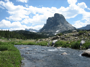 |
| Buffalo Head and the South Fork of the Little
Wind River |
Stopping short of my preferred destination of
Little Valentine meant that we’d probably miss the Cirque of the
Towers on this trip and have to cross Washakie Pass then backtrack to
Big Sandy the way we came from Skull Lake. I was very disappointed but
knew I’d be back to this wonderful place soon enough and began mentally
planning the next big trip. Besides, from what I’d read on the internet,
the trip from our camp up to Washakie Pass looked really good.
I slept horribly again despite the soothing sounds
of the river just a few hundred feet away. Part of the problem was the
nighttime temperatures. I had anticipated temps dropping down into the
30’s at night but these never came---for the entire trip. I’m
not even sure we saw 40’s for lows as it stayed quite warm the entire
time. Even using my Western mountaineering bag as a comforter covering
only my torso did no good. I was much too warm every night we were out.
|


